


 108 / 127

103
National Dairy Development Board
Part VII :
Agriculture
Dairying in ODISHA
-
A Statistical Profile
2016
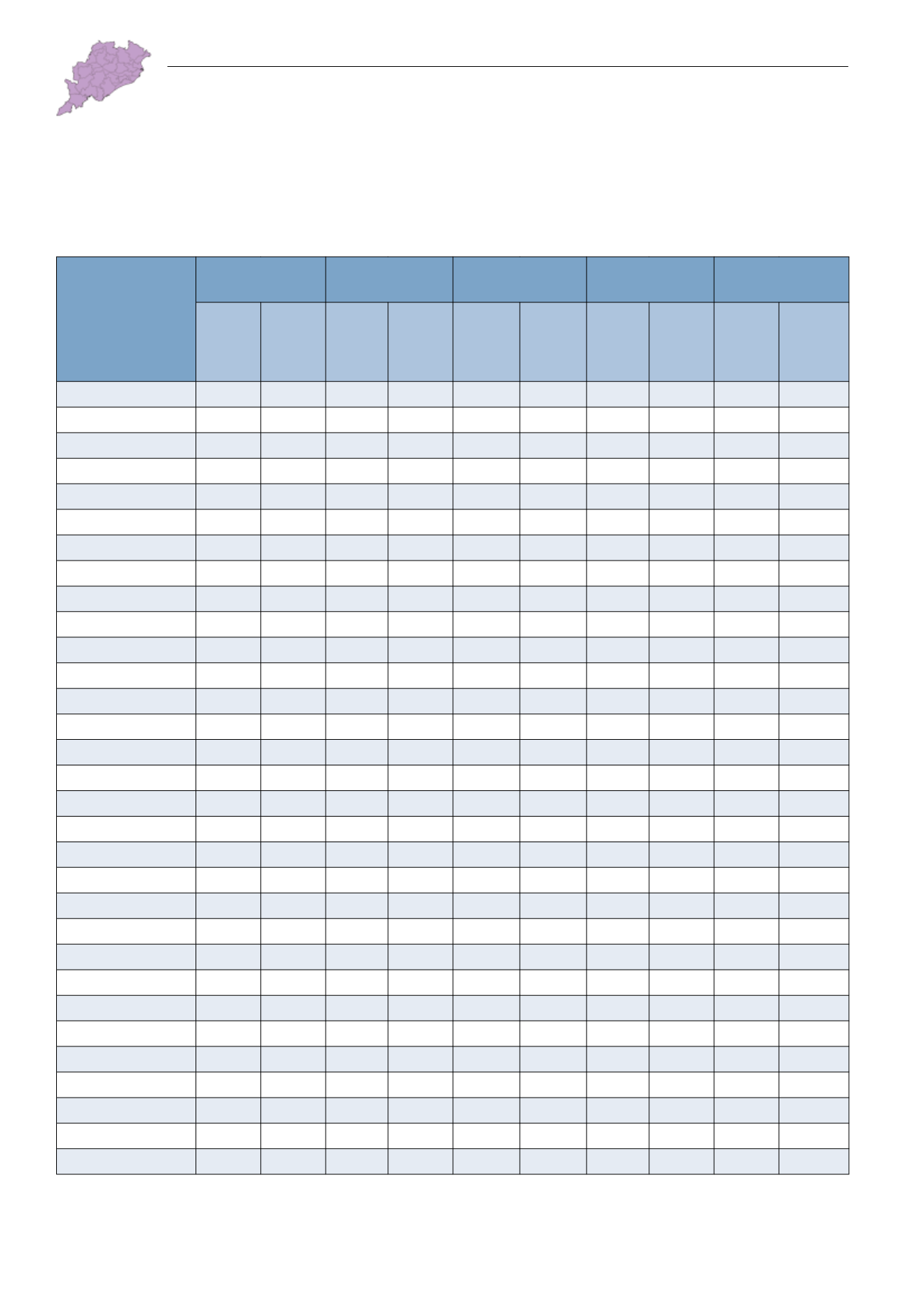
VII.2. Land Use Pattern
Table VII.2.1: District-wise Land Use Pattern
(‘000 ha)
Districts
Geographical
Area
Forest
Permanent
Pasture
Fallow Land Net Sown Area
2003-04
2013-14
2003-04
2013-14
2003-04
2013-14
2003-04
2013-14
2003-04
2013-14
ODISHA
15,571 15,571 5,813 5,813 443 494 803 985 5,796 5,424
Anugul
623
638 272
272
11
36
32
54
202
179
Balangir
657
657 154
154
32
46
15
67
335
292
Baleshwar
363
381
33
33
12
16
20
64
234
191
Bargarh
584
584 122
122
10
20
26
23
320
332
Baudh
345
310 128
128
17
17
33
8
88
85
Bhadrak
268
250
10
10
14
11
13
11
178
170
Cuttack
373
393
79
79
10
11
35
32
165
157
Debagarh
278
294 156
156
8
5
20
7
64
62
Dhenkanal
460
445 174
174
10
8
65
72
168
134
Gajapati
385
433 247
247
6
12
3
6
80
76
Ganjam
871
821 315
315
20
20
25
23
381
389
Jagatsinghapur
197
167
13
13
7
7
19
21
96
90
Jajapur
289
290
72
72
4
4
27
9
153
141
Jharsuguda
220
208
20
20
31
20
13
30
76
61
Kalahandi
836
792 314
254
23
23
27
59
364
335
Kandhamal
765
802 571
571
10
10
22
27
118
107
Kendrapara
255
264
25
25
8
8
26
31
140
135
Kendujhar
830
830 310
310
34
20
16
53
296
245
Khordha
289
281
62
62
6
5
11
27
134
108
Koraput
790
881 188
188
28
45
44
51
276
272
Malkangiri
619
579 335
335
14
21
27
21
135
136
Mayurbhanj
1,042 1,042 439
439
24
28
78
94
399
356
Nabarangapur
529
529 246
246
4
8
18
13
212
181
Nayagarh
424
389 208
208
12
4
1
9
134
126
Nuapada
341
385 125
185
10
2
22
4
158
186
Puri
305
348
14
14
11
9
41
56
141
134
Rayagada
758
707 281
281
26
26
75
38
152
160
Sambalpur
670
666 363
363
12
13
33
32
178
179
Subarnapur
234
234
41
41
13
13
6
14
109
121
Sundargarh
971
971 496
496
16
26
11
29
309
284
Source: : Various Issues of Odisha Agriculture Statistics, Directorate of Agriculture and Food Production, Govt. of Odisha.